Specializing in the sales, maintenance, and technical guidance of surveying and mapping instruments
Service hotline
158-9286-8846
Specializing in the sales, maintenance, and technical guidance of surveying and mapping instruments
Service hotline
158-9286-8846

contacts:蒋超
telephone:15892868846
sebsite:www.sczydx.com
postbox:517914222@qq.com
address:No.1204,Building 3,No.595,Jinzhou Road,Jinniu High tech Industrial Park,Chengdu,Sichuan Province
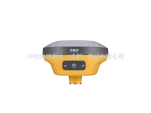
Sichuan RTK Measuring Instrument Company introduces the performance of Beidou Haida V200 to you:
Lightweight and compact/fast measurement,Zhonghaida brand RTK-V200 makes operation simpler and quickly improves measurement efficiency.Compact body/Support for Beidou-3/Inertial Navigation/CORS services/Full protocol built-in radio/No three-year traffic
Small and compact body,not tiring to work
The main engine has a diameter of 13.2cm and weighs only 0.82kg
Light EPP material instrument box,sturdy,wear-resistant,and impact resistant
Lightweight design reduces the weight of the entire box by 50%
Equipped with a 2m centering lever,it is more portable for self driving in the field;
All constellations,all frequency bands,fixed fast
Support Beidou-3 satellite signal
Search and solve satellites up to 50+
More sensitive signal reception and adaptive anti-interference support for single Beidou solution
New inertial navigation,can be measured with just a shake
Fast initialization in 8 seconds,stable and difficult to exit
High frequency without delay,instant measurement
Built in CORS service for instant testing
Direct measurement of cGCS2000 coordinates
Full protocol built-in radio station
Three adjustable power levels,supporting network relay
410MHz~470MHz
116 frequency bands(of which 16 are configurable)
Built-in eSIM card+4G communication
Built in eSIM network chip,including three years of 4G traffic
Simultaneously reserve a Nano SIM card slot to support 4G connectivity
RTK V200 Technical Parameters
GNSS configuration channel count:400+
BDS:B1,B2,B3
GPS:L1,L2,L5
GLONASS:L1,L2
GALILIEO:E1,E5a,E5b
SBAS:Support
QZSS:Support
Output format ASCII:NMEA-0183,binary code
Output frequency 1Hz-20Hz
Static data format GNS,Rinex dual format static data
Differential format CMR,RTCM2.X,RTCM3.0,RTCM3.2
Network mode VRS,FKP,MAC;Support for NTRIP protocol
System Configuration Operating System Linux Operating System
Start time 3 seconds
Data storage with built-in 8GB ROM,supporting automatic cyclic storage of static data
Accuracy and reliability[1]RTK accuracy plane:±(8+1)×10-6D)mm(D is the distance between the measured points)
Elevation:±(15+1)×10-6D)mm(D is the distance between the measured points)
Static accuracy plane:±(2.5+0.5×10⁻⁶D)mm(D is the distance between the measured points)
Elevation:±(5+0.5×10⁻⁶D)mm(D is the distance between the measured points)
DGPS precision plane accuracy:±0.25m+1ppm;Elevation accuracy:±0.50m+1ppm
SBAS accuracy 0.5m
Initialization time<10 seconds
Initialize Reliability>99.99%
Communication unit I/O port USB Type-C interface,SMA interface
Built-in 4G network communication,built-in eSIM4 card,including 3 years of internet access fee,can be connected upon startup
WiFi communication 802.11 a/b/g/n access point and client mode,providing WiFi hotspot services
Bluetooth communication®4.2/2.1+EDR,2.4GHz
Internal radio station:
Power:0.5W/1W/2W adjustable
Frequency band:410MHz~470MHz
Protocol:HI-TARGET,TRIMTALK450S,TRIMMARK III,TRANSEOT,SOUTH,CHC
Number of channels:116(of which 16 are configurable)
Intelligent alignment of sensor electronic bubbles
Tilt measurement with built-in high-precision inertial navigation,automatic attitude compensation,8mm+0.7mm/°tilt(accuracy within 30°<2.5cm)
User interface button,one power button
LED reminder light,satellite light,signal light,power light
WEB UI built-in web page for receiver settings and status viewing
Function application OTG function,NFC flash connection,WebUI interaction,USB firmware upgrade
Intelligent application,intelligent voice,function self check,intelligent CORS
Remote service message push,online upgrade,remote control
Cloud service device management,location service,collaborative work,data analysis
Physical characteristics:The host battery is equipped with a high capacity lithium battery of 6800mAh/7.4V,and the working time of the network mobile station is greater than 10 hours
External power supply supports USB port charging and external power supply
sizeΦ132mmx67mm
Weight≤0.82kg
Power consumption 4.2W
The material shell is made of magnesium alloy material
Environmental characteristics dustproof and waterproof IP68
Anti drop and resistance to natural drop of a 2-meter high measuring rod
Relative humidity non condensing
Working temperature-30℃~+70℃
Storage temperature-40℃~+80℃


PHONE:15892868846

EMAIL:517914222@qq.com

ADDRESS:No.25 Renmin North Road Section, Jinniu District, Chengdu, 1-4