Specializing in the sales, maintenance, and technical guidance of surveying and mapping instruments
Service hotline
158-9286-8846
Specializing in the sales, maintenance, and technical guidance of surveying and mapping instruments
Service hotline
158-9286-8846

contacts:蒋超
telephone:15892868846
sebsite:www.sczydx.com
postbox:517914222@qq.com
address:No.1204,Building 3,No.595,Jinzhou Road,Jinniu High tech Industrial Park,Chengdu,Sichuan Province
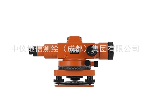
Sichuan Surveying and Mapping Instrument Company introduces Bofei Haiyun DZS3-1 to you:
A level is an instrument used to establish a horizontal line of sight and measure the height difference between two points on the ground.The principle is to measure the height difference between ground points based on the principle of leveling.The main components include telescope,tube level(or compensator),vertical axis,base,and foot screw.According to structure,it is divided into micro tilt level,automatic leveling level,laser level,and digital level(also known as electronic level).According to accuracy,it is divided into precision level and ordinary level.
The level instrument emerged after the invention of telescopes and levels in the 17th to 18th centuries.In the early 20th century,a micro tilt level was produced based on the production of an internal focusing telescope and a coincidence level.In the early 1950s,an automatic leveling instrument appeared;In the 1960s,a laser level was developed;In the 1990s,electronic or digital levels emerged.
A level that uses a laser beam instead of manual reading.Guide the laser beam emitted by the laser into the telescope tube and shoot a horizontal laser beam along the collimation axis.
Using the monochromaticity and coherence of the laser,a piece of glass or metal plate with a certain shading pattern can be assembled in front of the objective lens of the telescope,that is,the zone plate,to generate diffraction interference.After focusing through a telescope,a bright and fine cross shaped or circular laser spot is obtained within the focusing range of the zone plate,thereby more accurately aiming at the target.If equipped with automatic tracking photoelectric receiving targets on the front and rear leveling rulers,leveling measurement can be carried out.In construction surveying and large-scale component assembly,a laser level is commonly used to establish a horizontal plane or line.
The digital level is an advanced Z level,paired with a specialized barcode level,and automatically obtains the barcode reading of the level through the built-in digital imaging system,eliminating the need for manual reading.This instrument can greatly reduce the labor intensity of surveying and mapping operations,avoid subjective reading errors caused by human factors,and improve measurement accuracy and efficiency.


PHONE:15892868846

EMAIL:517914222@qq.com

ADDRESS:No.25 Renmin North Road Section, Jinniu District, Chengdu, 1-4